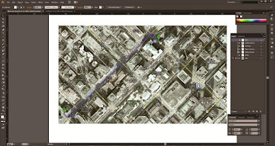
My friend, Abby, asked me to create her invitations for her upcoming nuptials that's taking place this summer. Part of her invitation package is a Directions Card that consists of a map.
I have never created a map from scratch before, so I wasn't too sure where to start. I did some googling and got some pointers from this handy online tutorial.
Here are the steps that I took:
1) Take a Print Screen of the satellite image of the area that you want to create

2) Using Adobe Illustrator, create a new layer. With the Pen tool, trace all the major streets and roads
 |
| You may notice that the satellite map and the roads don't quite match up. I had already shrunk the map that I made prior to taking screen shots of my project. |
4) If you want your start and end points to stand out, instead of tracing the building/area, you may want to consider using a graphic.
5) With the Pen tool, draw the destination path
6) Hide the layer with the satellite map. Crop and edit the map as needed, and you're done!
Got another way of creating maps? Please share :)


Wow, I'm very impressed! You make it seem so easy.
ReplyDeletewhoooooooooaaaaa WINNIE! that was . . . GOOD.
ReplyDeleteNo updates for 2 months. This blog is dead?
ReplyDeleteI got busy with other stuff. Good stuff coming soon! Where's my guest post? I thought you were going to do one on toothpaste.
ReplyDelete